 1 month ago
21
1 month ago
21
From the alpine majesty of the Hooker Valley to the turquoise vistas of the Abel Tasman, these are the best day hikes on New Zealand’s South Island
New Zealand’s South Island is a masterpiece of contrasts, where snow-draped Alps rise sharply above sapphire lakes, and pristine beaches curve gently into sheltered bays. Ancient forests, glacier-fed rivers and dramatic fiords create a landscape that feels both untouched and overwhelmingly grand. It’s a place where every turn reveals a new scene worthy of a postcard.
If you don’t have the time or legs for the Great Walks of New Zealand, then these South Island day hikes are the next best thing. With magnificent views on par with some long-distance hiking trails, these short and sweet hikes showcase the best of New Zealand’s diverse and often bizarre scenery without the aching feet, sweaty backs and muddy boots.
South Island’s best day hikes
These day hikes are ideal for travellers who want to experience the island’s most accessible yet truly breathtaking trails. We’ve selected routes that offer epic scenery without requiring technical experience or multi-day commitments.
They’re also perfect for those who love immersing themselves in raw nature by day but still appreciate the comfort of a warm shower, fine cuisine and a plush bed by night. That’s where New Zealand luxury tours strike the perfect balance: all the adventure that comes with an iconic landscape paired with premium lodging and thoughtful touches that make every evening feel like a reward.
1. Hooker Valley Track
Distance: 10km
Duration: 3 hours
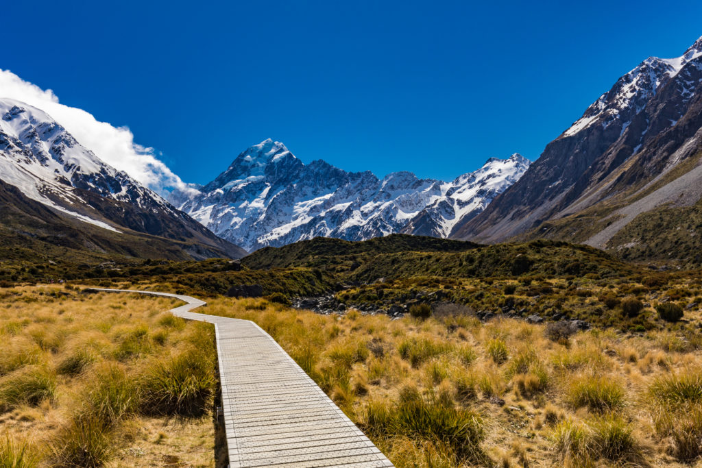 Mvaligursky/Dreamstime Hooker Valley is a New Zealand icon
The Hooker Valley Track is one of Aoraki/Mount Cook National Park’s most iconic walks, leading you through a glacier-carved valley framed by towering peaks and swinging suspension bridges. The track is wonderfully accessible yet spectacular throughout, offering views of the Mueller Glacier, alpine tarns, and finally the iceberg-dotted Hooker Lake with Aoraki rising dramatically behind it. It’s a well-graded, mostly flat route, making it suitable for most fitness levels while still delivering that quintessential South Island grandeur.
2. Lake Matheson/Te Ara Kairaumati Walk
Distance: 2.6km
Duration: 1 hour
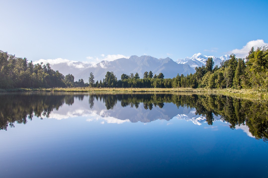 Atlas & Boots One of the most serene views in NZ
My favourite of our South Island short walks showcases New Zealand’s highest and second-highest mountains. Aoraki/Mount Cook at 3,724m (12,218ft) and Mount Tasman at 3,497m (11,473ft) rise above the calm, reflective waters of Lake Matheson, creating one of the most postcard-perfect views in all of New Zealand. Both peaks can be seen mirrored, from all angles, in the serene lake nestled amid lush and ancient forest.
3. Ōkārito Trig Walk
Distance: 4.2km
Duration: 1 hour
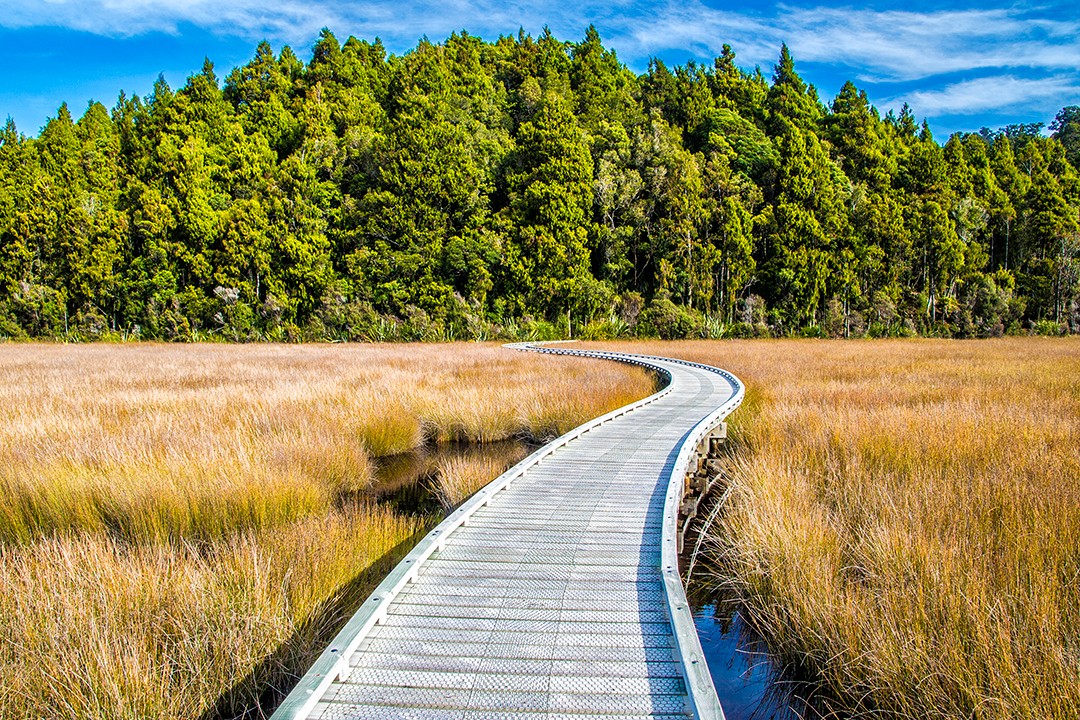 Atlas & Boots The Trig Walk is one of several trails around Ōkārito Lagoon
Just a few kilometres to the north of Franz Josef Glacier sits the coastal settlement of Ōkārito and the Ōkārito Lagoon. There are several walks in the area, but we chose the Trig Walk, which takes in part of the Wetland Walk across the lagoon.
The Trig Walk is a short but vigorous hike up to a lookout where an awesome panoramic vista across the surrounding ocean, estuary, sea cliffs, lush forest and, of course, the Southern Alps awaits.
4. Franz Josef Glacier / Kā Roimata o Hine Hukatere Walk
Distance: 5.4km
Duration: 1-2 hours
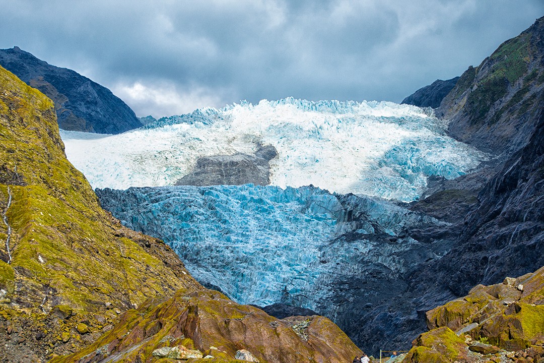 Atlas & Boots Franz Josef Glacier at the end of the Valley Walk
Located in Westland Tai Poutini National Park on the west coast of South Island, Franz Josef Glacier once stretched from the mountains right to the sea. Following millennia of retreat, the glacier is now 19km inland and accessible only by helicopter. The heli-hikes are often cancelled due to bad weather, so the next best thing is the Valley Walk to a viewing point close to the terminal face.
5. Moeraki Boulders Walk
Distance: 1km
Duration: 30 mins
 Atlas & Boots Moeraki Boulders, a group of spherical rocks at Koekohe Beach on the Otago
The Moeraki Boulders are a collection of near-perfect spherical rocks scattered along Koekohe Beach on the Otago coast. These concretions, some two metres wide and weighing several tonnes, have fallen down to the sea after the erosion of the coastal cliffs above. Boulders continue to be exposed as waves wash away the mudstone that embeds them in the cliffs.
The boulders are just a short walk down to the beach and along the shoreline from the car park, where a cafe boasting excellent views of the coast is positioned.
6. Blue Pools Track
Distance: 1.5km
Duration: 1 hour
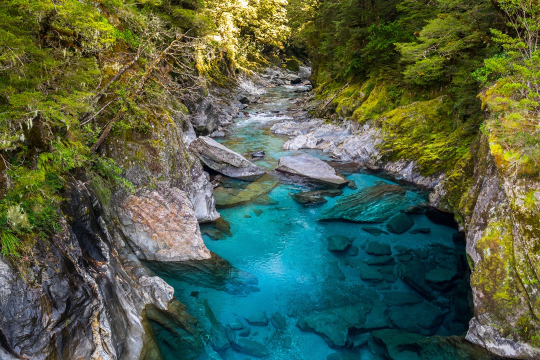 Dreamstime The freshwater Blue Pools near Makarora
Secluded in the depths of a quiet beech and podocarp forest is a collection of crystal clear pools of deep, icy water. The tranquil pools flow into the Makarora River, where two swing bridges provide excellent views. It’s possible to cross the bridges and continue along the trail for views along the gorge.
The recently restored track is located on the Haast Highway about 20 minutes west of Makarora.
7. Pancake Rocks and Blowholes Walk
Distance: 1.1km
Duration: 30 mins
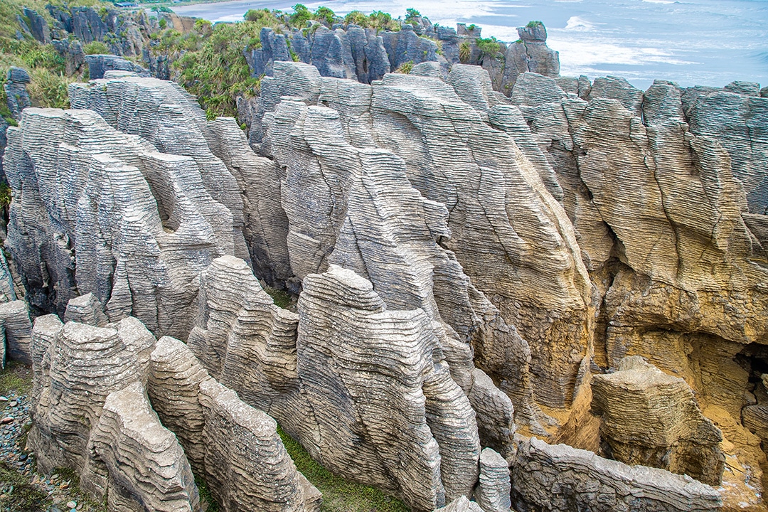 Atlas & Boots The Punakaiki Pancake Rocks at the end of the trail
The Pancake Rocks and Blow Holes at Punakaiki mark the end of the soon-to-be 10th Great Walk of New Zealand. The Paparoa and Pike29 Memorial Track is opening in 2019. Positioned beside the wild Tasman Sea, the curious limestone rock formations are at their most spectacular at high tide. The route is boardwalked throughout with several lookouts and interpretive signs.
8. The Chasm Walk
Distance: 1km
Duration: 30 mins
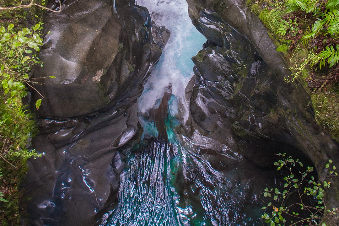 Atlas & Boots Glacial waters course through The Chasm
After a morning exploring the nearby Milford Sound, we stopped off at The Chasm. The short walk crosses two footbridges over the Cleddau River with spectacular views of a series of waterfalls. The fast-flowing and swirling waters have sculpted rounded shapes and basins in the rock over thousands of years, making for a dramatic scene in the lush forest.
9. Kaikoura Peninsula Walkway
Distance: 11.7km
Duration: 3 hours
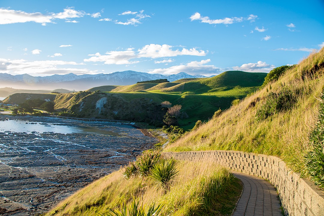 Atlas & Boots New Zealand’s Southern Alps meet the Pacific Ocean
At Kaikoura, New Zealand’s Southern Alps dramatically meet the Pacific Ocean. Jutting out from the rugged east coast of the South Island, the peninsula has some excellent cliff-top viewing platforms. Backed by the snow-capped Seaward Kaikoura Range, this is a wonderful place to spot a range of wildlife, including whales, dolphins, fur seals, penguins and albatross.
The full hike can take up to three hours, and you can make it longer or shorter if you wish. The best place to start the walk is at Point Kean, but the full hike can begin in the township at either South Bay or West End.
10. Abel Tasman Coast Track (Marahau to Apple Tree Bay)
Distance: 12km
Duration: 3-4 hours
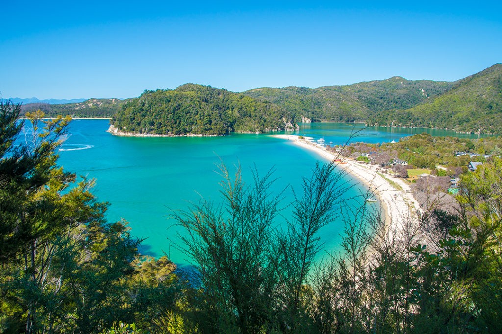 Atlas & Boots Hiking the Abel Tasman Coast Track
The Abel Tasman Coast Track is a sun-drenched blend of golden beaches, turquoise bays, and gentle forested headlands – perfect for walkers who like a mix of scenery without strenuous climbs. The popular return route from Marahau to Apple Tree Bay treats walkers to sheltered coves, curious weka and clear water lapping at warm sand, making it feel more like a tropical escape than a traditional tramp. With its well-formed track and regular water-taxi access, it’s easy to tailor the walk to your pace while soaking up that famously serene Abel Tasman atmosphere.


 English (US) ·